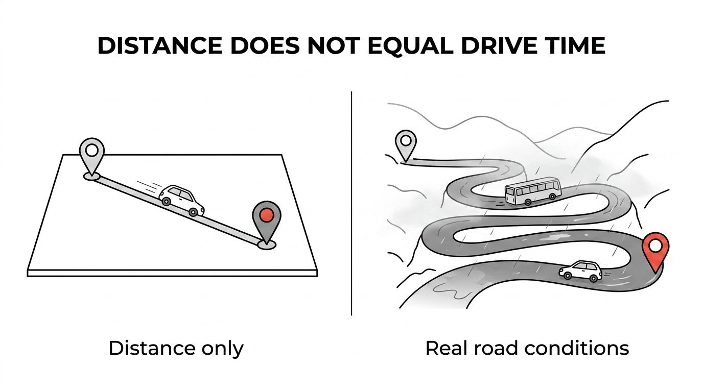
Kerala is one of the most rewarding places in India to experience by road. It is also one of the easiest places to misread from a map. Distances may look modest, yet travel times can stretch because settlements are continuous, traffic patterns are mixed, and mountain sections demand patience.
That contrast becomes even sharper when travelers start asking about hill routes. A drive from Kochi to Munnar or from Kozhikode to Wayanad is not just about kilometers. It is about gradients, curves, rain, visibility, and the pace needed to stay safe and comfortable.
Official guidance supports that view. Kerala has an unusually dense road system, and state and national disaster agencies consistently point to heavy rain and landslide-prone hill terrain as the main reasons road conditions can shift quickly.
How Kerala road conditions vary by region
Kerala’s road network is extensive. A state disaster assessment reported roughly 152,000 km of roads, including about 1,500 km of national highways, around 4,300 km of state highways, and roughly 28,300 km of major district roads. That same assessment noted that roads carry the great majority of passenger and freight movement in the state.
In practical terms, this means road travel is central to almost every itinerary. Airports, backwaters, beaches, wildlife areas, and hill stations are all tied together by road, not by long-distance rail within the tourist circuit itself.
Still, “Kerala road conditions” is not one single thing. The experience changes noticeably by region.
| Road setting | Typical feel in fair weather | Main concern in heavy rain | Best traveler approach |
|---|---|---|---|
| Cities and towns | Busy, slower, frequent junctions | Waterlogging, congestion, poor visibility | Start early and allow buffer time |
| Coastal and midland roads | Scenic, steady movement, mixed traffic | Local flooding and reduced sight lines | Drive conservatively and avoid night arrivals |
| National and state highways | Better continuity, but still populated | Traffic disruption and wet-surface braking distance | Keep speeds moderate, not optimistic |
| Ghat roads in hill districts | Narrower, steeper, winding | Landslides, fallen rocks, fog, edge erosion | Use daylight hours and check advisories |
The biggest planning mistake is assuming all routes operate at the same pace. They do not. A flat route of 80 km can feel simple. A mountain route of the same length can take far longer and demand much more concentration.
Why ghat driving in Kerala needs a different mindset
A ghat road is a hill road that climbs or descends through the mountains, usually with hairpin bends, steep sections, and changing surface conditions. In Kerala and the nearby Western Ghats, these roads connect the plains to hill regions like Munnar, Wayanad, Thekkady, Vagamon, and parts of Palakkad and Pathanamthitta.
The scenery is outstanding.
The driving, though, needs discipline rather than confidence alone.
Unlike broad expressways in some other parts of the world, Kerala’s hill roads often combine curves, narrow shoulders, local traffic, buses, bikes, pedestrians, and weather shifts within the same stretch. That means a driver may need to brake for a sharp bend, give way to a bus, and then deal with mist or rain just minutes later.
This is why experienced local drivers often appear calm rather than fast. Smooth control matters more than speed on these roads.
That approach broadly matches Trafik Start’s explanation of eco-driving, which emphasizes smoother braking, calmer acceleration, and better overall control rather than aggressive inputs.
Rain, visibility, and landslide risk on Kerala hill roads
Monsoon does not mean travel should stop. Yet it is also the biggest factor behind changing road conditions. India Meteorological Department advisories have explicitly warned that very heavy rainfall in Kerala can trigger landslides, rock falls, mudslides, waterlogging, traffic disruption, and reduced visibility. Those same advisories also note that roads, highways, bridges, and drainage channels can be blocked or washed out during intense weather events.
That is especially relevant for ghat driving.
State disaster-assessment findings after major floods showed significant road damage in hill districts including Idukki, Wayanad, Pathanamthitta, and Palakkad. The report also estimated damage to about 580 km of national highways during that period, with landslides and slope failures featuring strongly in the hill terrain.
The Western Ghats are geologically sensitive, and the Geological Survey of India classifies large parts of this wider mountain system as landslide-prone. Its guidance is direct: full prevention is not realistic, so hazard identification and route awareness are necessary parts of safer movement through these areas.
A detail many travelers overlook is roadside embankments. GSI guidance notes that embankments along roadsides are particularly susceptible to failure. So the risk is not only a dramatic landslide from a mountain slope above. It can also be erosion, slippage, or debris affecting the road edge itself.
What official Kerala hazard maps mean for route planning
Kerala State Disaster Management Authority publishes hazard information that is useful well beyond emergency planning. Its hazard map resources include landslide susceptibility zones for all 14 districts, along with road-accident blackspots and landslide-susceptible village lists.
This matters because it shifts the conversation from general worry to practical awareness. Travelers do not need to fear every hill road. They do need to respect that some belts are more sensitive than others, especially during or after sustained rainfall.
If a route passes through a district with known landslide susceptibility and there has been intense rain, a same-day route check becomes sensible rather than optional. The safest travel plan is usually the one that stays flexible.
A strong pre-drive routine often includes:
- Weather forecast check
- Local traffic updates
- Daylight departure
- Fuel topped up
- Extra time buffer
- Backup halt option
That last point is often the most valuable. If weather worsens, the ability to delay, reroute, or break the drive can turn a stressful day into a manageable one.
Common signs that a ghat road needs extra caution
Road conditions in the hills do not always fail dramatically. Small warning signs often appear first. GSI guidance advises road users to watch for collapsed pavement, mud, fallen rocks, and debris flow indicators. It also warns that landslides may occur weeks or even months after intense storms.
That means a bright day after earlier rain is not automatically risk-free.
When driving in a hill section, pay attention to cues like these:
- Fresh mud on the road: A sign that runoff or a small slope slip may have happened recently
- Scattered stones or pebbles: Often an early hint of movement higher up the slope
- Broken road edge: A warning that the shoulder or embankment may be weaker than it looks
- Sudden standing water: Not just a puddle, but possible drainage blockage or wash across the surface
- Low cloud or dense mist: A major visibility issue on bends and descents
- Stopped local traffic: Usually worth treating as a signal, not an inconvenience
Local drivers tend to read these details quickly. Visitors should slow down and do the same.
Practical driving habits for Kerala ghat roads
A successful hill drive in Kerala is usually uneventful. That is the goal. Smooth inputs, measured speeds, and good timing make a huge difference.
Many travelers are comfortable on regular highways but less familiar with mountain technique. On ghat roads, downhill control is as important as uphill momentum. Braking late into every curve creates heat, stress, and uneven control. A steady pace works far better.
Many travelers are comfortable on regular highways but less familiar with mountain technique. On ghat roads, downhill control is as important as uphill momentum. Braking late into every curve creates heat, stress, and uneven control. A steady pace works far better.
A few habits consistently help:
- Use lower gears: They help manage climbs and descents without overworking the brakes
- Keep left with discipline: Especially on blind bends where larger vehicles may occupy space
- Avoid overtaking on curves: The road may look clear for a second and close instantly
- Increase following distance: Wet roads and mixed traffic reduce reaction margins
- Respect buses and trucks: They know the route, but they also need more room
- Pause when needed: A short stop is better than pressing on while tired or tense
Night driving deserves separate mention. Even in dry weather, many hill sections feel more demanding after dark. Add rain or fog, and the difficulty rises quickly. If there is any choice, schedule ghat travel in daylight.
Self-drive or chauffeur-driven transfer?
This is not only a comfort question. It is a route-matching question.
Self-drive can work well for travelers who are already confident in India, comfortable with mountain roads, and prepared to adjust plans around weather. For first-time visitors, families with children, older travelers, or anyone moving during monsoon months, a trained chauffeur often makes the trip more relaxed and far more predictable.
The difference is not just who holds the steering wheel. It is the combination of local road reading, timing, and real-time decision-making.
Situations where a professional driver may be the better call include:
- Airport to hill station arrivals after noon in monsoon season
- Multi-stop routes with hotel check-ins on the same day
- Travel with seniors or young children
- Routes through Idukki, Wayanad, or other hill belts after heavy rain
- Itineraries with early flights or fixed sightseeing slots
For premium or tailor-made holidays, this is often why private transfers remain so popular. They reduce fatigue, lower uncertainty, and allow travelers to enjoy the landscape instead of managing every bend, honk, and weather shift themselves.
How to time Kerala road travel during monsoon and post-rain periods
Monsoon does not mean travel should stop. It means timing becomes more strategic. Heavy rain can affect road conditions directly through waterlogging and visibility loss, and indirectly through slope instability that may continue after the skies clear.
That post-rain window is easy to underestimate.
IMD advisories warn that localized flooding can close underpasses and slow traffic in low-lying areas. GSI guidance adds a second layer: slope failures can happen after intense storms, not only during them. So a smart travel plan considers both current rainfall and recent rainfall history.
A few timing principles are especially useful:
- Travel earlier in the day when visibility is better
- Keep hill drives shorter during active rain spells
- Avoid tightly packed same-day transfers and sightseeing
- Reconfirm road status on the morning of departure
- Stay open to one-night rerouting if local authorities advise it
For visitors, that flexibility often protects the overall trip. Missing one scenic stop is a small issue. Being caught on a blocked hill road is not.
What “good road conditions” in Kerala really looks like
Travelers sometimes expect a simple rating system: good roads, bad roads, safe roads, unsafe roads. Kerala does not fit neatly into that model. Many routes are perfectly serviceable, well-used, and beautiful, yet still slow. A road can be fine in the morning and problematic by late afternoon if rain intensifies. A hill drive can be enjoyable in daylight and tiring after dark.
So the better question is not whether Kerala roads are good or bad.
It is whether the route, season, weather, departure time, and driver experience fit each other well.
When those pieces match, road travel across Kerala can be one of the finest parts of the trip, especially on the climb into the Ghats, where forests thicken, the air cools, and each bend opens to a new view. When they do not, even short distances can feel much longer than expected. That is why careful planning, current advisories, and a realistic pace matter so much on this part of South India.